
I’ve recently blogged about the lack of safe ways to cross the Conestoga Parkway by bicycle. This topic has got me thinking about how to get more people on bicycles. I’m ai fairly experience and confident cyclist and I’m going to ride my bike across the city regardless of bike lanes. I’m not afraid of riding on streets with traffic in the absence of bike lanes (as long as it’s not during rush hour). However, this barrier will prevent other people from riding bikes. People need to feel safe at all times during their ride, whether it’s a commute during rush hour or a Sunday afternoon ride.
In my slow and easy rides during my concussion recovery, I’ve toured around on some of the local multi-use trails in K-W. I like that I can ride from trail to trail, and I don’t mind crossing the busy streets. But as I’ve stated, I’m an experienced cyclist. To get more people cycling on these trails, they need to feel safe ALL the time, and that includes at all road crossings.
On some of my recent urban bike rides, I’ve ridden along the local Spur Line and Laurel Trail multi-use paths. I understand that there’s been effort to connect these paths and in many places, this connectivity is evident. However, there are a couple of crossings that are confusing and can be dangerous for novices.
In the map below (from Google Maps), I’ve circled two locations that were confusing. #1 (in the south) is on the Spur Line trail, crossing Weber Street at George Lippert Park. Coming from the south on the Spur Line, I didn’t know whether to cross at the rail road tracks or continue north along the path/sidewalk and cross at the light. I chose to do the latter, but the flow of the trail takes riders across Weber at the rail road tracks.
The second confusing point was on the Laurel Trail heading north east from Uptown Waterloo. To get there from the Spur Line Trail, there’s are various trail intersections in Uptown Waterloo. You can continue towards King Street, or turn north on the Laurel Trail. Crossing Erb Street at Peppler Street has a traffic light for bike crossing, but once you cross, you have to ride on the opposite side of the road, then cross Peppler to get to the Laurel Trail. This trail then continues towards Weber Street. Once you reach Weber Street (#2 in the map below), the trail stops and there’s no clear way to proceed across Weber. Having checked maps before my ride, I knew I had to cross Weber, but the nearest traffic light was down at Lincoln, so I’d either have to ride on busy Weber Street with cars driving over 60 km/h (and no bike lane) or ride along the sidewalk to the light. OR… I could wait and cross Weber when it was clear. I chose the latter and waited for a gap in the traffic, but I know that families with young kids on bikes would not feel safe doing so.

Maybe there’s a grand plan to connect the trail better, and if so, that’s great news. But until then, these confusing and dangerous crossings will continue to prevent more people from using the trails.
One final note regarding the LRT. I was on the newly-opened portion of King Street last weekend and saw this sign (in the upper right corner of the photo):
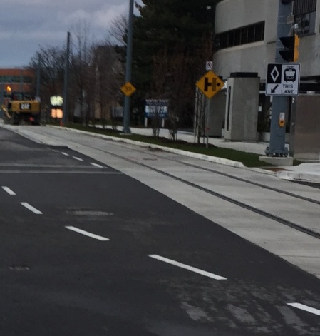
I’ve always thought that the diamond on this sign meant this lane was for cyclists. Does this imply that the LRT tracks are going to be shared by cyclists and the LRT? If so, how do we share the lane? And is it fair to ask cyclists to ride skinny tires in a lane with LRT tracks? This seems like a recipe for cyclists to crash.
I was disappointed when King Street (and Caroline Street) were re-opened recently with no bike lanes. King Street, in particular, because they’ve added the LRT tracks, AND they still have on-street parking, but no lane for cyclists. There still is plenty of parking in the area and on-street parking is not necessary. This could be removed for bike lanes, in my opinion.

Design for pedestrian refuge on Laurel Trail and Weber just got released. Gotta write these more often! 🙂 https://twitter.com/uu_john/status/806491510971604994
I think a diamond is a reserved lane of some sort, not necessarily for cyclists (e.g. HOV lanes on highways are also diamonded and definitely not for cyclists).
LikeLike
From: http://www.mto.gov.on.ca/english/dandv/driver/handbook/section3.1.1.shtml
“These signs mean lanes are only for specific types of vehicles, either all the time or during certain hours. Different symbols are used for the different types of vehicles. They include: buses, taxis, vehicles with three or more people and bicycles. ” So the signing is saying it’s an LRT lane, not a LRT/bike lane. So no bike lane?
LikeLike
So no bike lanes 😦
LikeLike
I think we’re supposed to ride on the 21′ wide sidewalks as shown in the artist’s rendering here:
http://tritag.ca/bikeuptown/
LikeLike
Yeah, I’m amazed they still have on-street parking and WIDE sidewalks but no bike lane…
LikeLike