
When I first took interested in bikepacking, a Google search took me to a review of a bikepacking adventure by a guy named Miles Arbour. In 2016, he rode a system of trails and roads called the Central Ontario Loop Trail, or COLT. His article got me interested, and my brother Greg and I started to gear up in late 2016 in preparation for riding all or portions of the COLT in 2017.
If you Google “COLT trail cycling map”, you’ll see Miles’ article, plus links to various maps. I don’t know if there’s an “official” COLT map or route, but here’s the best I could find:

You’ll notice that in the northwest and northeast, there are some disconnected parts, and you’ll also notice that the Trans Canada Trail (TCT) cuts west to east, offering an alternative to going right down to Lake Ontario.
After studying this map, plus Miles’ route, I thought that the best option for us would be to start and finish near Haliburton (where my sister lives) and cut across the TCT (thus avoiding the trip down to Lake Ontario, where my understanding was that there was a lot more traffic and paved roads). We’d ride counterclockwise. By sticking to the TCT, we would be able to ride from Haliburton south to Lindsay, east to Campbellford and north to Bancroft almost exclusively off-road. The final leg (Bancroft to Haliburton) would include some road (and a lot of gravel options). Suffice it to say, that for the COLT, there is no official complete route and there are many options available.
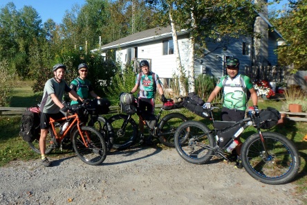
Greg and I recruited two friends, Hal and Matt, to join us on this four-day adventure. Hal had recently completed a 15-day solo bikepacking trip of the Colorado Trail, and Matt has travelled all over the world on his bike. After examining route options, it looked like our version of COLT would be a little over 400 km, so we’d be averaging around 100 km each day.
Day 1 – Haliburton to Emily Provincial Park (100 km)
We started our adventure near Donald, Ontario (about 10 km south of Haliburton) on the Haliburton County Rail Trail.
This rail trail was mixed surface with hard-packed dirt, to loose gravel, to wash-board. I’d previously cycled some of this trail before (in Crank the Shield mountain bike events). With a net downhill, we made good time to Kinmount, where we took a short break to view the falls.

The rail trail continues south from Kinmount (where it becomes the Victoria Rail Trail) towards Lindsay. The rail trail in the Lindsay area is in good shape. The surface is smoother than north of Kinmount.
Before I continue, I should mention that we planned to ride mainly on the rail trail for a couple of reasons. First, it’s how the COLT is mapped, and second, it took us away from car traffic. There are advantages and disadvantages to riding long stretches of rail trail:
Advantages:
- It’s built for trains, so it’s relatively flat
- It takes you away from cars and trucks, so it’s more peaceful and safer
- It winds around some very pretty lakes
- There are some impressive bridges (both old and new) across rivers
Disadvantages:
- It’s built for trains, so it’s relatively flat.
- It’s a constant grind for cycling, particularly on loaded down fat bikes
- Some stretches can be sandy or wash-boardy, which can be tiring (Spoiler alert: See Day 3)
Our planned lunch stop on Day 1 was Fenelon Falls, and we stumbled upon a place called Sweet Bottoms Coffee on Lindsay Street. At Sweet Bottoms, we met Wayne, who offered to fill our water bottles while we waited for our lunch. He then took us to the back of his shop, where he has a small bicycle museum! He’s a collector/rebuilder of vintage road bikes and has a very impressive collection.

The second half of Day 1 took us through Lindsay, where we stopped for a few groceries and some craft beer. One more hour of riding brought us to Emily Provincial Park, where we camped for the night.


Day 2 – Emily Provincial Park to Marmora (120 km)
Day 2 was our longest day and we’d be riding along the Trans Canada Trail, which we picked up just south of the park.


At about 20 km into the ride, we rode through Peterborough before heading towards Hastings, where we stopped for lunch. In Hastings, the rail trail had led us to a bridge that we couldn’t cross, even on foot.

For lunch, we found a local place to eat.

It was becoming really hot and I used this stop to refill my water bottles and hydration bladder, since we still had 60 km to ride to Marmora. At around 80 km, we rode through Campbellford, where our navigator Matt found a suspension bridge high above the Trent River.

After that stop, we continued east before turning north (just before Stirling) onto the Hastings Heritage Trail (side note: You can take this trail south towards Trenton and Lake Ontario. Alternatively, you can continue east on the TCT towards Tweed).
The final push north to Marmora was tough. It was hot and I was getting really tired. After long days like this, my mind goes to a dark place. Every cell in my body wants to quit, except for that small part of my brain that only wants to get to the finish. I focus on turning the pedals just to keep the bike moving forward. We finally made it to Marmora where Matt had ridden ahead and got a campsite. When the three of us showed up, Matt offered to ride back into town to buy groceries (Tip: It’s good to have the right mix of riding companions… like Matt, who was our navigator and evening grocery shopper!)
We stayed at Crowe Valley Campground for $45. They had showers, running water, and we were surrounded by trailers, most of which were empty.

Day 3 – Marmora to Bancroft (100 km)
After a long 120 km day, I thought Day 3 would be “easy”, at 100 km. I was wrong. As the trail continued north, its condition started to get worse. The puddles were fun, but the varying surface was challenging (bumpy, loose, and beach-sandy for long stretches), plus it was a net up hill. Other riders of COLT earlier this year (here’s the link) quoted this part of the trail like this: “It was making my eyeballs rattle in my head!“. I can’t possibly describe this part of the trail any better than that.

We stopped for lunch near a place called Gilmour. We found a shady, grassy area where we ate food that we had brought with us.
The scenery on this stretch of rail trail was beautiful. The leaves on the trees are just starting to turn red, yellow, orange. And there are beautiful wetlands and streams all along the way, as well as rock cliffs along the side of the trail. As we neared Bancroft, the trail gets sandier. This was a tough grind, slightly uphill in soft, beach sand.

The sign that indicated we were in Bancroft was a welcome sight. Again, Matt had ridden ahead. We agreed to meet at the Bancroft Eatery and Brew Pub, where I had the tastiest burger ever (food always tastes better when I feel I’ve earned it).


Matt joined us for dinner then rode ahead to secure a campsite just north of town while the rest of us visited the brewery. We stayed at River Bend Cabins Tent Trailer Park just north of Bancroft on a beautiful campsite right on the York River for just $25.

Day 4 – Bancroft to Haliburton (89 km)
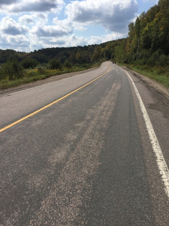
Day 4, the final day, would take us off the rail trail and onto paved and gravel roads. Matt plotted a route that would include some of the climbs in the area, as well as a stop for lunch in Wilberforce.
The hills were steep. Before lunch there were at least three big climbs. I refer to them as Alpe d’Huez, Mont Ventoux and Tourmalet. The day was the shortest at just under 90 km, but with the climbs, it was as tough than previous days.


The day ended with a fast down hill road into the town of Haliburton, followed by about 10 km of the Haliburton rail trail to Donald, where we started (with a short stop at the Little Tart for a pecan tart!).

One of the reasons I started this blog was to encourage people to cycle more. This adventure was challenging. I’m hoping more of my friends try this loop, or some variation of it. Here’s a map of the entire loop:

Things to think about if you’re considering riding COLT:
- Choose time of year wisely. We chose fall because we thought it would be bug-free and drier. It was, for the most part (some mosquitoes in the evenings). Temperatures were warm, but at this time of year, it could be a lot colder, so we lucked out with sunny days, cool evenings and no rain.
- You can do this loop by camping, like we did, but if you plan accordingly, you can stay at local motels, B and B’s, WarmShowers.org etc. and carry less gear.
- We chose to do this loop in four days, averaging over 100 km per day. If you’re less ambitious, you could ride less each day and stretch it out to 5 or more days.
- Or, if you’re a speed demon, you could do 150 km or more each day and do it in 2 or 3 days.
- The rail trail is more scenic towards the north, but less maintained (see Day 3)
- Something I learned from Matt – when you stop in towns, choose to eat at locally owned places rather than chain restaurants. The locals will share some great stories.
- Anyone who cycles semi-regularly can do this. If you take your time and plan properly, the distance can be done. I rode my fat tire bike with big 3.8″ tires. I could ride over anything that got in my way. A cyclocross or gravel bike would work, but some of the sandy and bumpy parts would be tough. A mountain bike would work just fine as well.
- For gear, I blogged in the summer about the packs and gear that I use here. I’ve since updated my sleeping bag to a down model that packs smaller. For food, I had dried food for three dinners (I used two of them). Breakfasts included a combination of oats and granola, plus bananas I picked up along the way. For lunches, we usually stopped in towns, except for Day 3. I also took a North Face rain jacket that I didn’t use, and a down jacket (from Costco) that was useful on the cool mornings. I took too much stuff (it was warmer than I thought it would be), but I always pack like that. I need to learn to lighten up. I carried two water bottles with electrolyte mix, plus a 2 litre hydration bladder in my backpack. On Day 2, I drank about 8 litres of liquids during the day! For snacks, I had nutrition bars, but I find those to be dry and hard to eat while riding. I need a better on-the-bike option. I also had Clif Shots during the rides.
- If you have any questions on routes, places to stop/stay/eat, fire me a note (or check out Miles Arbour’s blog on Riding Feels Good).

Awesome post Steve. Sounds like quiet the adventure. Glad too see you getting big km in 🙂
LikeLiked by 1 person
Great write up. You got me as a new subscriber now. Glad to see you are not to far from me. I like that.
LikeLiked by 1 person
Nice job guys! If anyone is looking for details on the full COLT, check out http://www.bikepacking.com/routes/central-ontario-loop-trail/
LikeLiked by 1 person
Thanks good information – roll on 2018 – I will give it a go for sure.
LikeLiked by 1 person
Great write up. Im starting to think about this for June.You mentioned the uncrossable bridge. What was the work around and it it reflected on your map?
LikeLike
Great write up. Im starting to think about this for June.You mentioned the uncrossable bridge. What was the work around and it it reflected on your map?
LikeLike
Hi Beth. The uncrossable bridge is easy to get around, through the town of Hastings. We ended up stopping there for lunch. If you zoom in on my Strava route for that day, you can see the “dead-end” just south of Hastings. We turned around and headed north to the town.https://www.strava.com/activities/1184188560
LikeLike
Thanks for the response. I’ll check out the Strava. This trip is floating to the top of my list.
Beth
Sent from my iPhone
>
LikeLike
Hi there, I’m contemplating doing this route with my 12 year old. Do you think it could be broken into 50 to 70 k days? Camping and/or staying in towns? Cheers, thanks for the information!
LikeLike
Hi Derek, Thanks for your note. It would take some planning, but you could do it with shorter days. There’s a longer stretch from Marmora north to Bancroft that doesn’t have a lot to offer. However, I found this link with some details. The route is a little different than mine, particularly in the north. https://ridewithgps.com/routes/14074803
LikeLike