I’ve been cycling in the Kitchener-Waterloo (KW) area for close to two decades – first as a mountain bike and adding road riding a few years later. In about 2012 I added gravel riding to my list and it has become my favourite kind of cycling. Back in those early years of gravel grinding, a “gravel bike” was anything that could be used on dirt and gravel roads. I had an old hard-tail mountain bike that I constantly tweaked to be suitable for these rides. Others were on cyclocross bikes or full mountain bikes.
In the years since those rides, I’ve explored the back roads around KW and seen the wonderful countryside that is mere minutes from the city. One of my early discoveries was the rail trail from Guelph to Goderich. The eastern part of this trail was in great shape – from just north of Guelph to just outside of Millbank – a distance of about 43 km – at which point, the trail got very rough and unrideable in places.
In early 2015, a bridge was built over a stream outside of Millbank, and the rail trail was re-surfaced. More recently, the trail was resurfaced further west to Milverton and in 2020, the amazing Project Red team from the Guelph-to-Goderich Trail Group completed grading and resurfacing of the entire trail all the way to Goderich! As recently as Fall of 2019, I rode westward past Milverton and a lot of the trail was unrideable. And yesterday (September 2020), I rode all the way to Goderich on hard-packed, crushed gravel trail.
This volunteer group has done an amazing job in a very short period of time. I encourage you make a donation here. This is the kind of initiative that will benefit anyone who lives near the trail. It’s already becoming a destination for out-of-town cyclists. Adjacent land owners are also getting into the game by offering rest stops and snacks!

Since I’d cycled the trail from Guelph to Milverton, my buddy John and I started from St. Jacobs and joined the Guelph-to-Goderich (G2G) trail just east of the town of Linwood. The ride from Linwood to Millbank is less than 10 km and we had the rare east wind behind our backs. In Millbank, there’s a short jog because there’s stream crossing where the bridge is missing. Also, Millbank has one of the finest bakeries in the area – Anna Mae’s. We were still near the beginning of our 130 km trek, so we bypassed the bakery and continued to Milverton, which is less than 5 km west of Millbank. There’s a longer bypass through Milverton because of another stream crossing over Smith Creek. This 4 km bypass took us through the town of Milverton before re-connecting with the G2G trail.
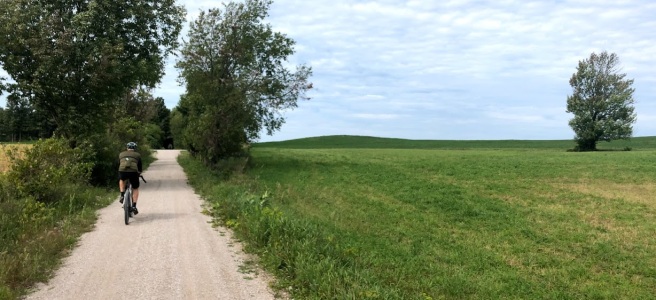
The section of trail from Milverton to Blyth is the newest freshly resurfaced part of the trail. It’s nearly 45 km between the two towns and the scenery is wonderful. There’s a combination of open farmers fields and tree tunnels.


In Blyth, we stopped to stretch our legs, having covered about 95 km. There’s an arch bridge as you enter the town:

The Blyth Arch Bridge. I didn’t explore that bridge/trail up above, but I’m left wondering… what’s up there?
Another 10-11 km took us to the Maitland River. The old train bridge is long gone, so there’s a detour that we took. I’ve talked to others who have carried their bike across the Maitland River, where the river doesn’t get deeper than about knee-deep. However, the detour includes Maitland Block Road, which is a very quiet and scenic gravel road and Little Lakes Road which includes an old steel bridge over the river:
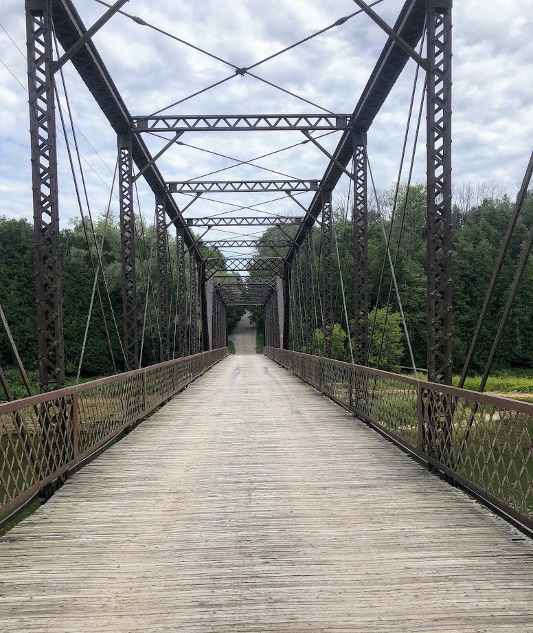
Little Lakes Road is another fantastic gravel road with some rolling hills, which made for a nice change after hours of flat, straight rail trail. The last part of the detour is a mostly-downhill trail heading north from the intersection of River Line and Hills Road. Then it’s a sharp left to pick up the G2G trail for the home stretch to Goderich.
The number of trail users grew as we got closer to Goderich, and the Menesetung Bridge marks the end of the G2G trail.

Overall, it was a fantastic ride. John and I had been trying to connect for a ride for, literally, years, and we finally did. John’s a fantastic ride mate – relaxed and strong (and even slowed down to my speed!) The east wind was a treat, and the G2G and back roads were wonderful. Goderich is a great destination for a day-trip, and just about the right distance for me. Goderich, by the way, has been named “Canada’s Prettiest Town”!
One final note, I’m fascinated by maps and the places I’ve cycled. My personal “heatmap” now extends to Lake Huron (from KW).

The entire length of the G2G trail is about 130 km from Guelph to Goderich. Since this trail passes north of KW, you’ll have to drive or cycle to a trail head in Elmira, West Montrose, Wallenstein, Linwood, or if you want to ride the entire trail, you could probably find parking in Guelph.
We’re so very lucky to have this trail so close to home. As I’ve mentioned in previous posts, gravel riding offers a contrast to riding on the paved roads. The rail trail is peaceful without any cars. It’s mostly flat and you get to see some of the country that you’d never see otherwise. Again, I encourage you to support the trails!

Steve, thanks for sharing your blog. You passed Lucie and I at km 96. We were headed in the other direction from Blyth so the same wind that was giving you a push was in our faces. How did you get home? Chris Neville
LikeLiked by 1 person
Hi Chris! Our partners drove to pick us up in Goderich!
LikeLike
The trail over the arch in blyth goes to the next sideroad and ends in a field, snowmobiles use it in winter, must have been an old railway route in the past, perhaps connecting to rail trail in mildmay years ago
LikeLiked by 1 person
Yeah makes sense. I looked at the satellite photos and couldn’t see the trail going anywhere.
LikeLike
Yes it is an old rail line that pre-dates the Goderich Guelph line – but there is a cool thing to check out and that is the train station for the old N-S line is still standing. Kids used to call it the witches house because of the unusual roof. It is a B and B now see this site http://blythstationhouse.tripod.com/
LikeLike
Thanks for the info!
LikeLike
I want to be able to do this someday.
LikeLiked by 1 person
Where exactly, do you get on this trail in Guelph? Thanks.
LikeLiked by 1 person
Hi Katie, Currently, the start of the trail is on Silvercreek Parkway, about 2.5 km north of Woodlawn (about 400 m south of Wellington Road 30. I think there are a few parking spots there. The CIty of Guelph is planning to connect this with the trail system in the city, but I don’t the the time lines for that development.
LikeLike
Can I ride with a road bike or does it have to be a hybrid or mountain bike?
LikeLike
If you have thicker (28mm) tires it could work. I wouldn’t ride on 23 or 25mm.
LikeLike
Hi Steve 1m doing it on saturday .. is it okay to go on solo ride? what things shoul i bring? i live on breslau ontario
LikeLike