I should start this blog by stating that it’s not about cycling. Instead, it’s a photo-journal of my recent trip to Newfoundland. Planning for this ten-day vacation to Western Newfoundland began in the winter when we decided to see the east coast after last year’s trip to Vancouver Island on the west coast of Canada. Newfoundland (and Labrador) was also the only province I hadn’t visited.
I’d toyed with the idea of bringing a bike along (even going so far as to borrow a bike box). I even considered renting a bike while in NL. However, after some internal debate, I decided to make this trip about hiking and walking, and take a break from cycling.
We didn’t want to spend a lot of time driving around the island, so we decided to focus on west coast. Fortunately, there’s a direct flight from Toronto t Deer Lake, which is just outside of Gros Morne National Park on the west side of the province know as “The Rock”.
After a few delays in our flight, we arrived in Deer Lake and made the short drive to Rocky Harbour, where we stayed just one night before driving north towards St. Anthony. The drive is about four hours and we stayed two nights in a tiny town called Raleigh. On the drive, we stopped for a quick vist at The Arches Provincial Park.

From our base in Raleigh, we visited the Nordic ruins at L’Anse Aux Meadows, the Burnt Cape Ecological Reserve and the town of St. Anthony.


At Burnt Cape, we parked the car at the base of a rough gravel road and proceeded to walk along the road. At one point, I stopped walking and heard absolutely nothing. No wind. No birds or insects. No cars or people. No animals. Nothing. There wasn’t even any wind blowing upon me. I could finally understand what it means when people say “the silence was deafening”. I could see in all directions, but it felt like the silence was closing in on me, like a fog. It was both eerie and exhilarating.

From just outside our door in Raleigh, we were treated to an amazing sunset:

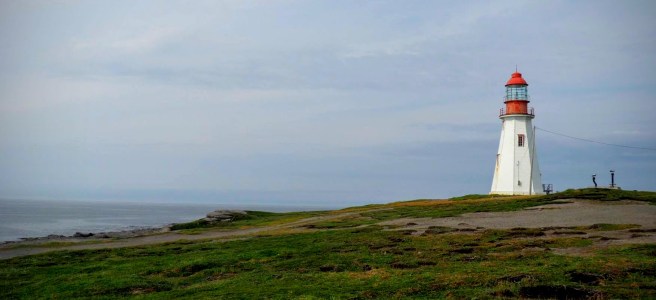
On our drive back south, we stopped at Port au Choix where we saw a lighthouse and a small heard of caribou (but no moose!).


Our next (and final) residence was in Norris Point, just around the bay from Rocky Harbour, where we stayed for six nights.
As we planned this trip and I began to learn about the area, my main goal was to do the difficult Gros Morne Mountain hike. It gains nearly 800 m of elevation and is 16 km in length. Hikers are warned it will take 6-8 hours and it’s very strenous. There are warnings to avoid the peak if it is obscured by clouds. Fortunately, we chose a day that had clear skies.
We packed about 8 litres of water (for the 3 of us), sandwiches for lunch and lots of energy bars and Skratch energy chews.
The hike to the BASE of the steep climb was about 3 km of constant (and often steep) trail. This took us nearly 2 hours on a hot clear day.

Once we got to the base of the “rock”, we had a decision to make. There was a sign that warned the climb up the rock and the return would take four hours and was very strenous. I was ready and so was my kiddo, so the two of us ventured on up the steep scree slope while J headed back.

This steepening slope of loose rock (called: Ravin the Gully) took us up 500 m in elevation in about an hour was very tiring in the hot sun. We were, however, rewarded with a view that left us speechless:


We even saw the elusive Ptarmigan, who was protecting her young:

The hike back down through Ravine Ferry Gulch, in theory, should have been easier than the climb, given that we had gravity on our side. However, with aging knees and hips, each step down was painful for me, even with the hiking sticks I carried. We took our time and stopped a lot (for rest, relief and to take photos!)

At 806 metres above sea level, Gros Morne mountain is the second highest mountain in Newfoundland. For comparison, the highest “peak” in Ontario is less than 700 metres above sea level.
I don’t have a bucket list, but this hike took us a full eight and a half hours and by the time we got back to our cottage, my legs were cramping and I was shivering, not from the cold, but likely from dehydration. We went through countless energy bars and 4 packs of Skratch chews, plus over 6 litres of water between the two of us. My hips, legs, knees, feet were sore.
I’ve been through some very difficult days on the bike, but this hike was quite possibly the most difficult one-day activity I’ve done. The climb up was tiring but very manageable. The hike down hurt with every step I took, and now, a week later, my knees still ache.
So back to the bucket list… If I had one, this hike would be on it and I could cross it off with great satisfaction.
The next day rained heavily (thankfully) so we relaxed in our cottage in Norris Point and rested our aching legs.
The next day, however, was another day that revealed the beauty of Newfoundland.
We booked a two-hour boat trip in Western Brook Pond through a former fjord. This pond lost is fjord status when isostatic rebound (the ground rises after being compressed by glacial ice) closed off the pond body from the ocean. Over many thousands of years, the water lost its salinity and the pond was no longer a fjord.
Fjord or not, the view was breathtaking. We were surrounded by cliffs that towered over us. These photos don’t reveal the scale of the cliffs, but they were hundreds of metres aboves. The highest peak was over 600 metres above us (the CN Tower, for comparison, is about 550 metres tall). Waterfalls fell through crevasses in the rock to the lake below.


After the boat cruise, we stopped at Green Point, where, at low tide, visitors can see millions of years of geologic history on a very short walk.
Without going into the geologic history of Newfoundland, I’ll summarize by saying this area has been studied by geologist from all around the world. Green Point contains a very important geologic unit that separates the Ordovidian from the Cambrian systems. I studied geological engineering, but promptly forgot all that I learned about geologic time scales soon after I graduated. Fortunately, much smarter scientists studied the fossils in the area and in 2000, these cliffs were designated as the Global Stratotype Section and Point for the base of the Ordovician system (OK, I had to look this up…).

The next day, we drove to the other side of Bonne Bay to visit the Tablelands. This area is another geologic wonder in the province. The bright orange/brown rocks that form the Tablelands are actually from the Earth’s mantle! Again, I won’t get into the Earth’s composition, but in summary… The Earth has a really hot core, then a mantle, then a crust. We live on the crust. The mantle is partly molten (think… “liquid hot magma”), and partly hardened rock.
It’s very rare to see rocks from the mantle on the Earth’s surface because the crust lies above it. The Tablelands, however, gives scientists a unique opportunity to examine these mantle rocks which, over millions of years, shifted around and up and down and ended up here. Vegetation is sparse on these rocks because their chemical composition doesn’t supply the necessary nutrients for plant growth.


If my legs were feeling up to it, I might have hiked to the top of the Tablelands, but that will have to wait for my next trip! I guess I’ll have to start a bucketlist after all…
The second last evening in Newfoundland found us in Rocky Harbour for dinner where the largest crowd I saw in my time on the Rock had gathered to witness a sunset over the harbour:

Summary of my 10 days in NL:
- The scenery is amazing and could very well be Canada’s best-kept secret.
- Gros Morne hike was very tough for me, but most healthy, active people could do it with proper footwear and supplies. We took over 8 hours, but we were passed by a lot of hikers who finished in 6.
- Tablelands is beautiful, and I’ve added the hike to the top to my bucketlist
- Green Point is a geologist’s dream and is indescribable to anyone else
- The weather can change in a moment. It can be foggy and you can’t see the mountains, and an hour later, it can clear up. Or vice versa.
- The people are very friendly
- I didn’t kiss a cod
- Everyone I talked to before my trip said to watch out for moose. I didn’t see any (other than a moose statue and a moose burger I had for lunch one day).
- We were a bit too late in the summer for iceberg viewing, but ….. bucketlist!
- Whale watching is also a possibility but we didn’t see any this time.
- Seafood was plentiful, but vegetables were not.
- There were no crowds. The biggest crowd was the sunset in Rocky Harbour (and a bus load of tourists in the Tablelands parking lot).

Great photos Steve. Sounds like you had a marvelous time. Brings back memories of when I cycled from Deer Lake up the coast and then back again several years ago.
LikeLike
Thanks Matt. That bike ride from Deer Lake would be fun! Lots of long climbs that I noticed as I was driving. The thought did cross my mind about riding there one day…
LikeLike
Wow so gorgeous there. Too bad it’s not easy making videos haha, that would’ve been cool to see. Keep up the great work Steve!
LikeLike